Wildlife of the Strath Taieri
Middlemarch’s unique landscape, from open farmland to rugged schist outcrops, is home to a rich variety of wildlife. The region supports an array of birds, reptiles, and insects specially adapted to this dry inland environment. From birds of prey soaring overhead to elusive skinks and hardy alpine insects, nature thrives here in often unexpected ways.
Middlemarch and the Strath Taieri region are home to a wide variety of native and introduced wildlife, offering visitors a real taste of Central Otago’s natural environment. Surrounded by wide open plains, rolling farmland, wetlands, and river systems, the area provides important habitats for many birds, animals, and freshwater species
Birdwatchers and nature lovers will be rewarded throughout the Middlemarch district, especially near rivers, wetlands, and sheltered valleys.
Commonly seen birds include:
- Pūkeko (Swamp Hen)
- Paradise Shelduck (Pūtangitangi)
- Southern Black-backed Gull (Karoro)
- Welcome Swallow (Warou)
- Fantail (Pīwakawaka)
- Bellbird (Korimako)
- New Zealand Falcon (Kārearea)
- Harrier Hawk (Kāhu)
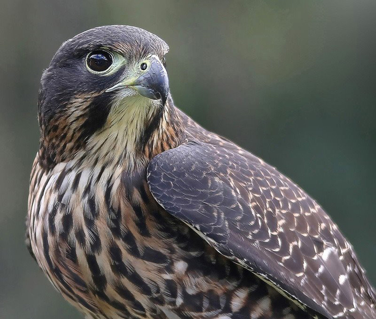
New Zealand Falcon Kārearea
Once spotted in the hills above Middlemarch and the Taieri Gorge, the New Zealand falcon (kārearea) is a fast, agile, and highly territorial bird of prey native to Aotearoa. Known for its rapid flight and aggressive hunting style, it favours habitats from native bush to open tussocklands.
Around Middlemarch, kārearea can often be seen soaring above rugged hill country, especially near rock outcrops or shrublands. They nest on cliffs or the ground, usually under rocks or vegetation. During breeding season, they fiercely defend their nests and are known to swoop at intruders. Their loud “kek-kek-kek” call is commonly heard.
Kārearea are listed as Threatened – Nationally Vulnerable, with their decline attributed to habitat loss, introduced predators, and collisions with human-made structures. Conservation efforts focus on predator control and preserving their natural habitats.
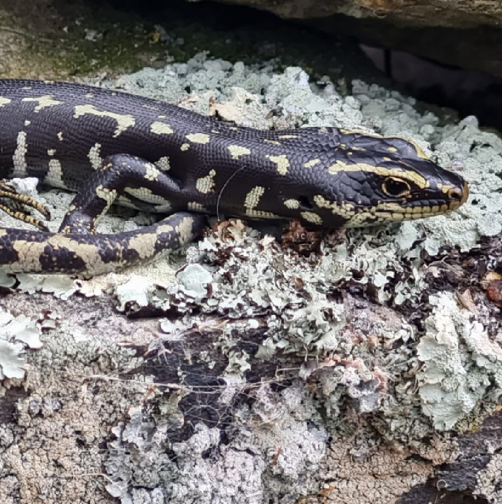
Otago Skink
A Rare Local Treasure
Found near Middlemarch, Otago skinks (Oligosoma otagense) are one of New Zealand’s rarest reptiles, found only in the Otago region. Known for their distinctive black, yellow, and green spots, they are well camouflaged among schist rock outcrops, often seen basking in sunny, tussock-covered landscapes.
Growing up to 300 mm long, these large skinks are omnivores, feeding on insects, fruit, and native plants. Their numbers have declined significantly due to habitat loss and predation.
Now critically endangered, Otago skinks face threats from cats, stoats, rats, hedgehogs, birds, and parasites. Conservation efforts focus on predator control and habitat protection, with ongoing monitoring in the region.
Photo credit Robin Thomas
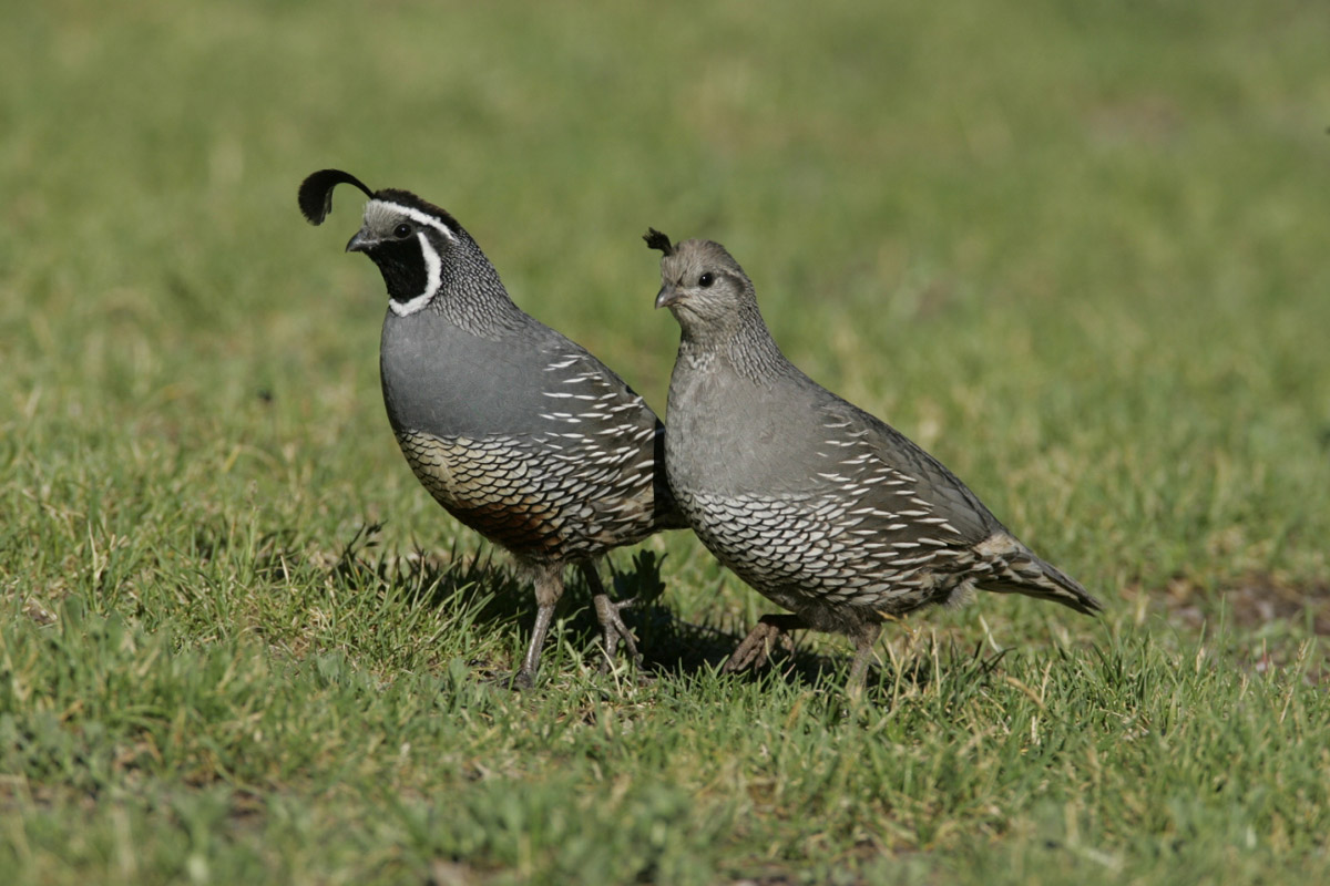
California Quail
Tikaokao
The California quail, or tikaokao, is a small, plump game bird introduced to New Zealand in the 1860s. It has since established widespread populations across both the North and South Islands, favouring open shrublands, grasslands, and hilly regions cleared of forest.
Males are easily recognised by their striking black face bordered with white and a conspicuous top-knot or plume. Females are duller in colour with a less prominent plume. These birds are known for their distinctive “Chi-ca-go” call, often heard during the breeding season.
In the Middlemarch area, California quail can often be spotted in open country, especially in hilly regions with sparse vegetation. Locals also report sightings of quail in the township itself. These ground-dwelling birds feed on seeds and insects and often form large coveys in the autumn to feed and roost together.
Middlemarch Geology
The Strath Taieri is a dramatic basin-and-range landscape shaped by ancient forces and rich geological history. Its foundation of 200-million-year-old schist contrasts with the much younger Rock and Pillar Range and Taieri Ridge, uplifted by tectonic activity just three million years ago. Striking rock formations, like the schist tors and volcanic remnants such as The Redan and Smooth Cone, define the region’s rugged beauty. Fossil-rich deposits and landmarks like the Armistice Tree on Smooth Cone offer a glimpse into both the prehistoric and human stories that shape this landscape today.